AI & Software · Tutorial
How to Plan and Share a Route With OpenStreetMap
Find driving, cycling or walking directions on OpenStreetMap, check the route, and share its link.
 By Tony Simons 4 min read
Disclosure: We may earn a commission when you shop through the links below. It never changes the verdict. Details
Disclosure
We may earn a commission when you shop through the links below. Opinions stay independent. Full disclosure
Sometimes you just need a route and a link you can send someone. OpenStreetMap can do that right in your browser, with a community-built map and a choice of routing services.
Quick answer: Open OpenStreetMap, choose the directions button beside the search box, enter a start and destination, then select car, bicycle or foot. Review the route and copy the browser’s address if you want to share it.
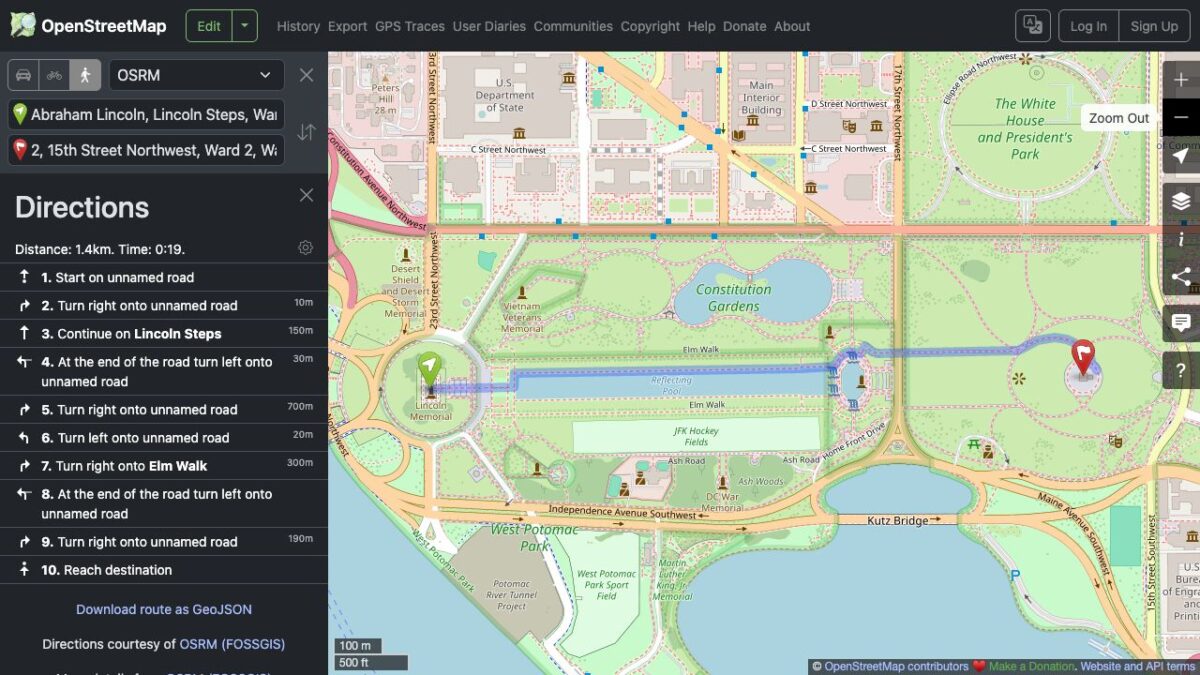
For this guide, we planned a route between the Lincoln Memorial and the Washington Monument on the OpenStreetMap website, switched from driving to walking, and reopened the walking-route address in a new browser tab. We did not travel the route or test turn-by-turn navigation. The interface and route results can change.
Featured image: OpenStreetMap route view captured firsthand. Map data © OpenStreetMap contributors, available under the Open Database License (ODbL); directions shown by OSRM (FOSSGIS).
Get directions between two places
- Go to openstreetmap.org and select the directions button next to the search field. You should see fields for a starting point and destination.
- Enter your starting place in the top field and your destination in the lower field. Include a city or other detail if a name could refer to more than one place. Press Enter after entering the destination.
- Check the resolved locations and pins. A plausible-looking result can still be the wrong branch or entrance. Edit the fields if either point is wrong.
- Choose the car, bicycle or walking icon above the fields. The site displays a route on the map and directions in the side panel. Check the selected mode before you rely on the result.
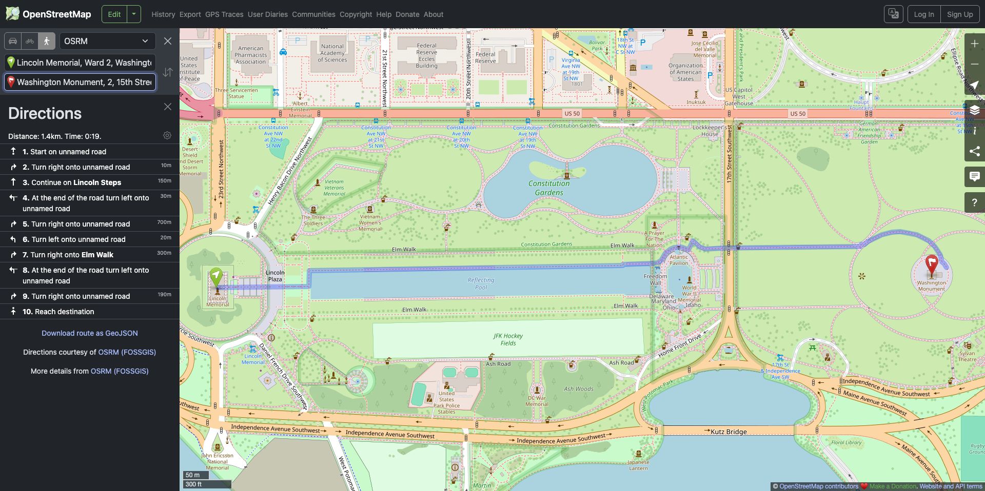
In our example, switching from car to foot changed the route from about 2.5 km to 1.4 km. That is an observation from this one test, not a promise about your trip: routing, starting points, map data and conditions can change.
Share a route without sharing the wrong thing
Once the directions you want are displayed, copy the URL from your browser’s address bar and send it to the person who needs it. We reopened our walking-route URL in a separate tab and saw the route and walking mode load again. The reopened page described the points using coordinates and nearby address names, so the labels may not look exactly like what you typed.
Check the link before sending it: route URLs can contain your start and end coordinates. If either location is private, share only with someone you trust, or use a nearby public meeting place instead. This is a route link, not proof that someone has downloaded an offline map.
When the route needs a second look
- The route looks strange: Check both pins and the selected travel mode. The directions-service menu offers different providers; results may differ. Try another available service and compare the instructions.
- A place cannot be found: Add the city, street or region, then check the suggested location on the map. You can also look for a nearby recognizable point.
- The walking route includes steps: Inspect the directions and map closely. Our test route listed Lincoln Steps. Do not assume a walking route is step-free or suitable for a wheelchair, stroller or other access needs.
- A road or path is closed: Follow signs and current local information. OpenStreetMap’s own usage guidance warns that map data may be incomplete or inaccurate. A route is a plan, not a guarantee about current conditions.
What OpenStreetMap is—and isn’t
OpenStreetMap is a community-built mapping project. The website lets you view its map and request directions from available routing services; it is one of many ways to use OpenStreetMap data. Its copyright and license page explains the open-data license and attribution requirements if you reuse a map in your own work.
If you need offline maps, accessibility-specific routing or a particular navigation feature, check that the app or service you choose supports it before leaving. The web route tested here is a useful starting point; double-check the details that matter for your trip.
The Inner Circle
One AI shortcut a week. Tested first.
The tools and tricks I actually kept using, sent once a week. Skip the hype threads.
- New verdicts and scores
- Same-day workflow tips
- No spam, unsubscribe anytime
Written by
Tony Simons
Tony has a bachelor's degree from the University of Phoenix and over 14 years of writing experience between multiple publications in the tech, photography, lifestyle, and deal industries.